India faces an Intelligence Gap in Infrastructure.
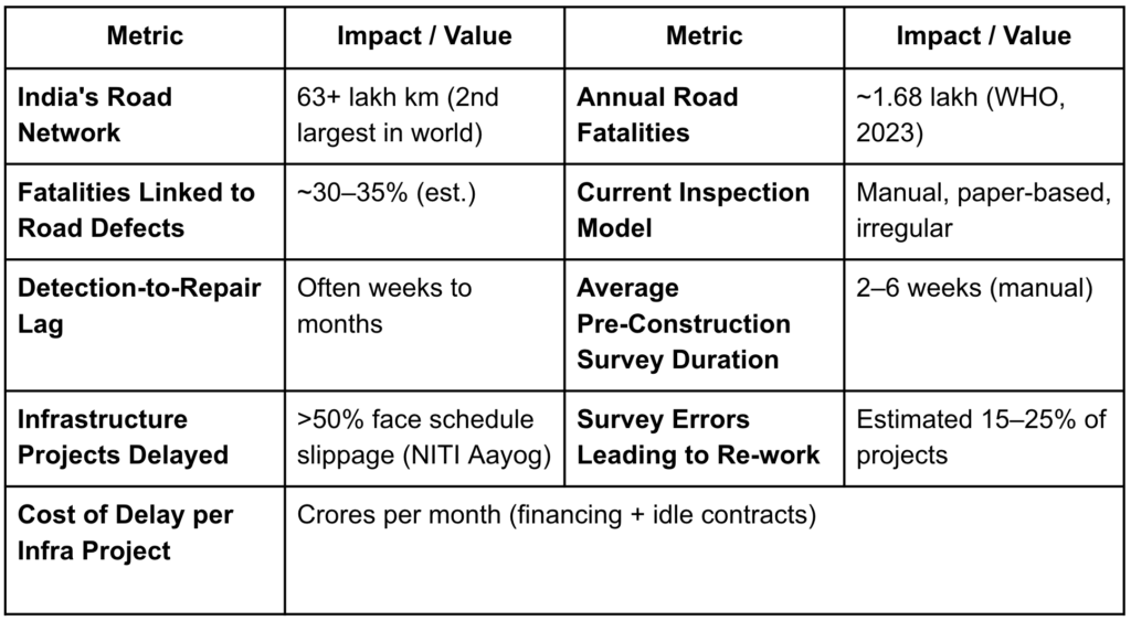
India faces a critical infrastructure intelligence gap, exemplified by its severe road safety crisis and bottlenecked pre-construction surveys. Accounting for nearly 11% of global road accident fatalities (over 1.68 lakh deaths annually), India’s roads are among the most dangerous, largely due to undetected defects like potholes and cracks. The current reliance on inefficient, inconsistent manual inspection teams fails to scale across the country’s 63+ lakh kms road network, leading to delayed reports and poor remediation prioritization.
Simultaneously, the country’s infrastructure ambitions are hampered by slow, inaccurate pre-construction land surveys, which rely on manual, vulnerable-to-error processes. Even a 10-day delay in this phase can cascade into months of project schedule risk and hundreds of crore in cost overruns.
Bharat-Drishti: SierraBlue’s Intelligent Camera Solutions
SierraBlue Innovations is building Bharat-Drishti, an AI-native edge perception platform designed to give physical devices their own brain. It is a powerful “Universal Core” computer powered by NVIDIA Jetson GPU hardware in conjunction with advanced AI-enabled software platforms. The Intelligent Surveyor platform is specifically designed for the Infrastructure sector.
3D Surveyor Platform closes the intelligence gap with AI. Traditional survey firms offer quality but are high-cost and slow, lacking a path to automation or scale. This model is inadequate for India’s pace of infrastructure growth. 3D Surveyor is purpose-built to close this gap to deliver structured, actionable insights—defect maps, survey data, risk scores—instantly, without relying on cloud connectivity. It is a deployable edge-AI device that transforms any vehicle or survey unit into an autonomous infrastructure intelligence platform.
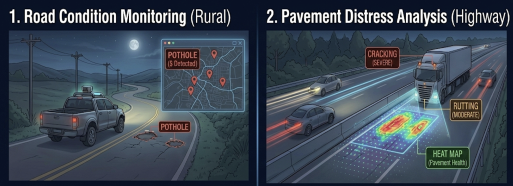
Prevention of Road Accidents by Automated Mapping of Roads. The 3D Surveyor’s road intelligence uses computer vision and AI to continuously scan road surfaces, identifying, classifying, and geo-tagging defects like potholes, cracks, edge damage, drainage failures. It can survey hundreds of km daily with consistent accuracy which provides maintenance teams with prioritized repair lists, enabling proactive defect repair before accidents occur.

Fast-tracking Field Surveys for Rapid Infrastructure Development. The 3D Surveyor uses AI-powered visual mapping to rapidly and accurately survey land, digitizing boundary and topography data. This automation reduces weeks of traditional fieldwork and manual entry to days, providing immediate digital outputs for legal, engineering, and project management use, thereby eliminating a major project execution bottleneck in India.
Substantial Market Opportunity: Act Now
BharatDrishti’s 3D Surveyor platform is uniquely positioned, capitalizing on both the National Infrastructure Pipeline (NIP) and the IndiaAI Mission. This synergy, combined with a first-mover advantage in infrastructure automation, makes the platform highly desirable for a diverse clientele. The customer universe spans public infrastructure bodies (like NHAI and state highway authorities), private contractors, and engineering/legal consultancies needing digitized survey data for construction and clearance.
One device. Three industries. Bharat-Drishti ensures instant processing, protects privacy, and works perfectly in remote areas with no internet—all while significantly cutting down on costs. As a matter of fact, this one device can be completely changed using downloadable software personas for different industries. For example, The Surveyor persona turns into an advanced surveillance system called The Sentry which can detect threats in milliseconds, while a different download can instantly turn the same hardware into KriishOS for smart farming.